Organic Maps is a free Android & iOS offline maps app for travelers, tourists, hikers, and cyclists. It uses crowd-sourced OpenStreetMap data and is developed with love by the community. No ads, no tracking, no data collection, no crapware.
This project aims at providing comfortable map viewing and navigation (routing) application for mobile devices. Particular stress lies with complete offline features (via pre-loaded offline map data) or economic internet usage.
Alpi Maps is a map application to help you prepare and enjoy your hike! Get all the info you need before you go, then enjoy all the data offline during your hike.
For anyone wondering “where do they get their money?”
It’s from businesses who buy their SDK. They (allegedly) don’t sell any of your data
Magic Earth is free for all our end-users but we also have a paid Magic Earth SDK for business partners. For instance Selectric.de (a supplier for navigation solutions for ambulances and fire trucks), Smarter AI (developing ADAS systems) or Absolute Cycling (using the platform on bicycles). For more info on the SDK, you can check magiclane.com.
Magic Earth is proprietary, though. You can believe their privacy policy, but I have trouble believing any privacy policy if I can’t see the source code.
Actually I think this is a pretty common thing. I know several people who use iPhones and other Apple products specifically to avoid the google alternatives.
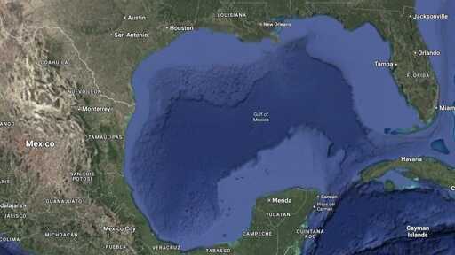
OpenStreetMap also needs to deal with this kind of thing. In this case, several people already tried to add it to the map in some form of other, but generally not as something to actually be shown. There is a looong discussion about it here https://community.openstreetmap.org/t/gulf-of-america-gulf-of-mexico/124571 . General opinion is that it is (or will be) “the official name that the US says it has”. In OSM you can invent tags for anything, so an object can have many names. Done like this, anyone using the data can still choose to give precedence to any “official US names that are not in common use yet”.
Later it may be upgraded ased on if it becomes a common alternative name, just in the US, or maybe beyond. All those options can have their own special tag. And only very motivated data users will ever show it to map users. But if you do a search for Gulf of America, you will be able to find it.


☞ https://www.openstreetmap.org/
https://f-droid.org/packages/app.organicmaps/ or https://github.com/organicmaps/organicmaps
Organic Maps is a free Android & iOS offline maps app for travelers, tourists, hikers, and cyclists. It uses crowd-sourced OpenStreetMap data and is developed with love by the community. No ads, no tracking, no data collection, no crapware.https://f-droid.org/packages/net.osmand.plus/ or https://github.com/osmandapp/Osmand
This project aims at providing comfortable map viewing and navigation (routing) application for mobile devices. Particular stress lies with complete offline features (via pre-loaded offline map data) or economic internet usage.https://apt.izzysoft.de/fdroid/index/apk/akylas.alpi.maps or https://github.com/Akylas/alpimaps
Alpi Maps is a map application to help you prepare and enjoy your hike! Get all the info you need before you go, then enjoy all the data offline during your hike.deleted by creator
What you use for email?
deleted by creator
I love the app MagicEarth for turn by turn navigation GPS. It uses OSM!
“Contains no known trackers” according to AuroraStore + free and no adds
https://www.magicearth.com/privacy/
will take a look, thanks
For anyone wondering “where do they get their money?”
It’s from businesses who buy their SDK. They (allegedly) don’t sell any of your data
Bottom of their faq
I haven’t been able to test it out yet, but it seems pretty decent
Magic Earth is proprietary, though. You can believe their privacy policy, but I have trouble believing any privacy policy if I can’t see the source code.
Ios: https://apps.apple.com/app/id1007331679 https://apps.apple.com/app/id934850257
Also fun fact the official apple maps app is mostly based on OSM.
people don’t degoogle to use apple instead
Actually I think this is a pretty common thing. I know several people who use iPhones and other Apple products specifically to avoid the google alternatives.
OpenStreetMap also needs to deal with this kind of thing. In this case, several people already tried to add it to the map in some form of other, but generally not as something to actually be shown. There is a looong discussion about it here https://community.openstreetmap.org/t/gulf-of-america-gulf-of-mexico/124571 . General opinion is that it is (or will be) “the official name that the US says it has”. In OSM you can invent tags for anything, so an object can have many names. Done like this, anyone using the data can still choose to give precedence to any “official US names that are not in common use yet”. Later it may be upgraded ased on if it becomes a common alternative name, just in the US, or maybe beyond. All those options can have their own special tag. And only very motivated data users will ever show it to map users. But if you do a search for Gulf of America, you will be able to find it.